

InfraDoctor®
Supporting Social Infrastructure Maintenance and Management with a System Leveraging GIS and 3D Point Cloud Data
Supporting Social Infrastructure Maintenance and Management with a System Leveraging GIS and 3D Point Cloud Data
A next-generation system that leverages GIS and 3D point cloud data to support the maintenance and management of infrastructure and structures, improving operational efficiency

- The trademark “InfraDoctor” is jointly registered by Shutoko Engineering Company Limited, Aero Toyota Co., Ltd., and Elysion Co., Ltd.
- Patent Registration Nos.6465421, 6503500, 6590653, 6682087, 6829747, 7336415, 7412118, 7644878
- Inspection Support Catalog Technology No.TN030014-V0023
- NETIS Registration No.KT-170012-A
Challenges InfraDoctor®
Can Solve
- Managing and searching paper-based asset registries is time-consuming and inefficient
- Site visits are required to understand on-site conditions
- Addressing aging infrastructure demands significant labor and time
Technology & Product Overview
InfraDoctor® is the core function of i-DREAMs, a next-generation integrated management system that the Metropolitan Expressway has operated since 2017. It is a cutting-edge system that leverages GIS and 3D point cloud data to support the maintenance and management of infrastructure and structures, improving operational efficiency.
WEB Available in two configurations: WEB (cloud-based) and ADVANCE (desktop)

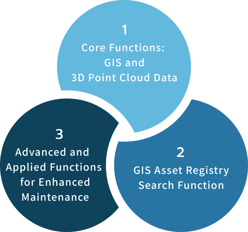
Three Core Functions
of InfraDoctor®
-
1Core Functions: GIS and 3D Point Cloud Data
Centralized cloud management of 360° video and point cloud data. Instant confirmation of site conditions from the office. Enables dimensional measurement and cross-section creation.
-
2GIS Asset Registry Search Function
Efficiently manage asset registry data by linking it with GIS and point cloud data. Build an efficient search system for inspection and repair history.
-
3Advanced and Applied Functions for Enhanced Maintenance
3D simulation, road surface condition surveys, progress monitoring, special vehicle passage assessment, AI-based column detection, and more.
1.Core Functions: GIS and 3D Point Cloud Data
Infrastructure Management Without Site Visits
Leveraging 3D point cloud data enables more advanced and efficient monitoring of road space conditions. InfraDoctor® centrally manages 3D point cloud data acquired by laser scanners, together with simultaneously captured video footage, on the cloud. Through 360° video viewing and 3D measurement, site conditions can be confirmed instantly from the office without visiting the site, reducing the workload involved in infrastructure management.
-
3D Dimensional Measurement
Every point in the 3D point cloud data carries precise 3D coordinates (X, Y, Z), enabling measurement of distances between two points from the office. This eliminates the need for traffic control previously required to measure intersection dimensions, and track closures previously required to verify clearances from railway structures and check construction limits.
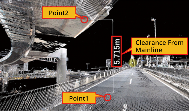
Distance measurement between two points using point cloud data
-
360° Video Viewing
Advanced, efficient monitoring of road space conditions through the use of 3D point cloud data. InfraDoctor® centrally manages 3D point cloud data acquired by laser scanners, together with simultaneously captured video, on the cloud. Through 360° video viewing and 3D measurement, site conditions can be confirmed instantly from the office without site visits, reducing the workload involved in infrastructure management.

Image reconstruction using 360° video and 3D point cloud data
-
3D Point Cloud Data Measurement
3D point cloud data is acquired using a Mobile Mapping System (MMS) — a vehicle equipped with laser scanners and cameras. For locations inaccessible to the MMS, such as under elevated structures or road shoulders, fixed laser scanners are used.

Measurement in progress using the MMS survey vehicle
2.GIS Asset Registry Search Function
Building User-Friendly Asset Registry and Inspection Result Search Systems Tailored to Administrator Needs
-
3D Dimensional Measurement
Maintenance and management operations rely on asset registry data for structures, attachments, underground utilities, and more. InfraDoctor® links this registry data with GIS and 3D point cloud data to achieve efficient management.
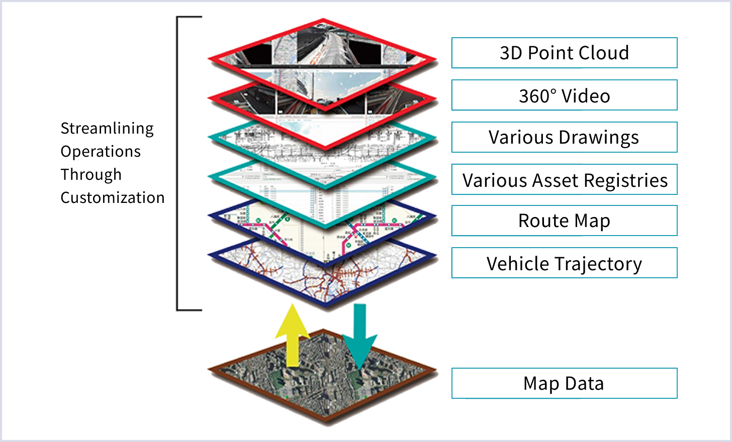
Asset registry search in operation
-
Inspection and Repair History Search System
The vast volume of inspection data and repair history accumulated through maintenance and management operations can be organized and stored using InfraDoctor®, enabling the construction of an efficient and effective search system.
-

Various asset registry search screens
-
Various asset registry search screens
-
3.Advanced and Applied Functions for Enhanced Maintenance
Six Applied Functions That Further Advance Infrastructure Management Using GIS and 3D Point Cloud Data
By using InfraDoctor®'s extended functions—including drawing creation, detection of pavement and wall surface deterioration, and 3D simulation—to further leverage GIS and 3D point cloud data, maintenance and management operations can be further enhanced.
-
Verification of Clearance from Adjacent Structures
Clearance distances from adjacent structures and outdoor advertising installations, as well as construction limits, can be verified using 3D point cloud data. By using InfraDoctor®, the need for surveying consultations and 3D measurements can be eliminated, enabling productivity improvements of more than 20 times compared to conventional methods.


By using InfraDoctor®, the need for surveying consultations and 3D measurements is eliminated, enabling productivity improvements of more than 20 times compared to conventional methods.
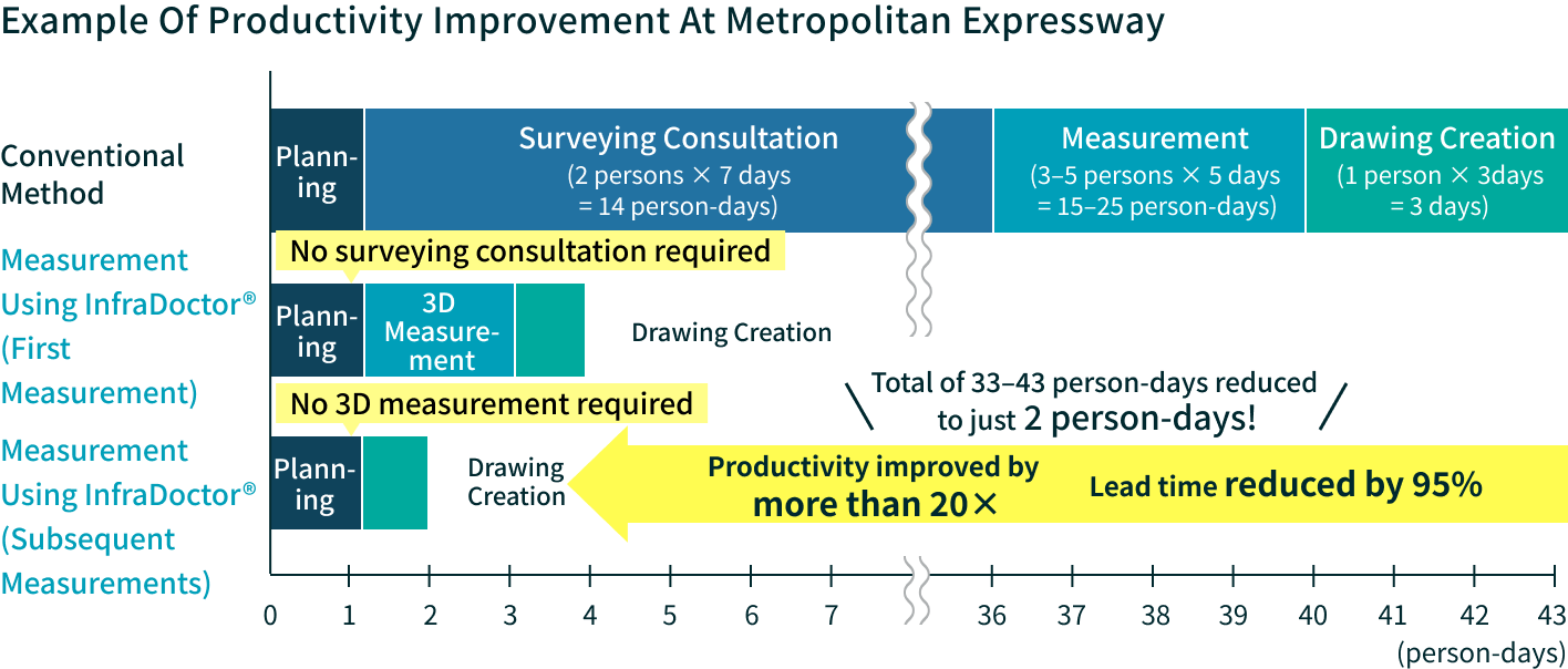
-
Efficient Progress Monitoring of Structures
By acquiring 3D point cloud data on a regular basis, changes in structural condition can be monitored. Comparisons between a reference surface and the positional data of each point cloud are displayed as contour maps, enabling efficient structural maintenance and management.

3D point cloud of the slope subject to progress monitoring

Condition at initial measurement

Simulated measurement results after 5 years
*Actual results may vary
-
Verification of Safety Measure Effectiveness from a Driver's Perspective
Using 3D point cloud data, simulations can be performed from the perspectives of drivers, pedestrians, and others by adjusting the viewpoint height.
For example, it can reveal that overgrown vegetation may obstruct the line of sight needed for safety checks when viewed from the low seating position of certain vehicles.
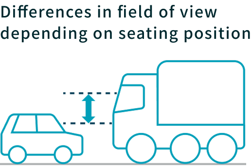

Field of view from a standard vehicle's viewpoint

Field of view from a large vehicle's viewpoint
-
Application to Special Vehicle Passage Permit Assessment
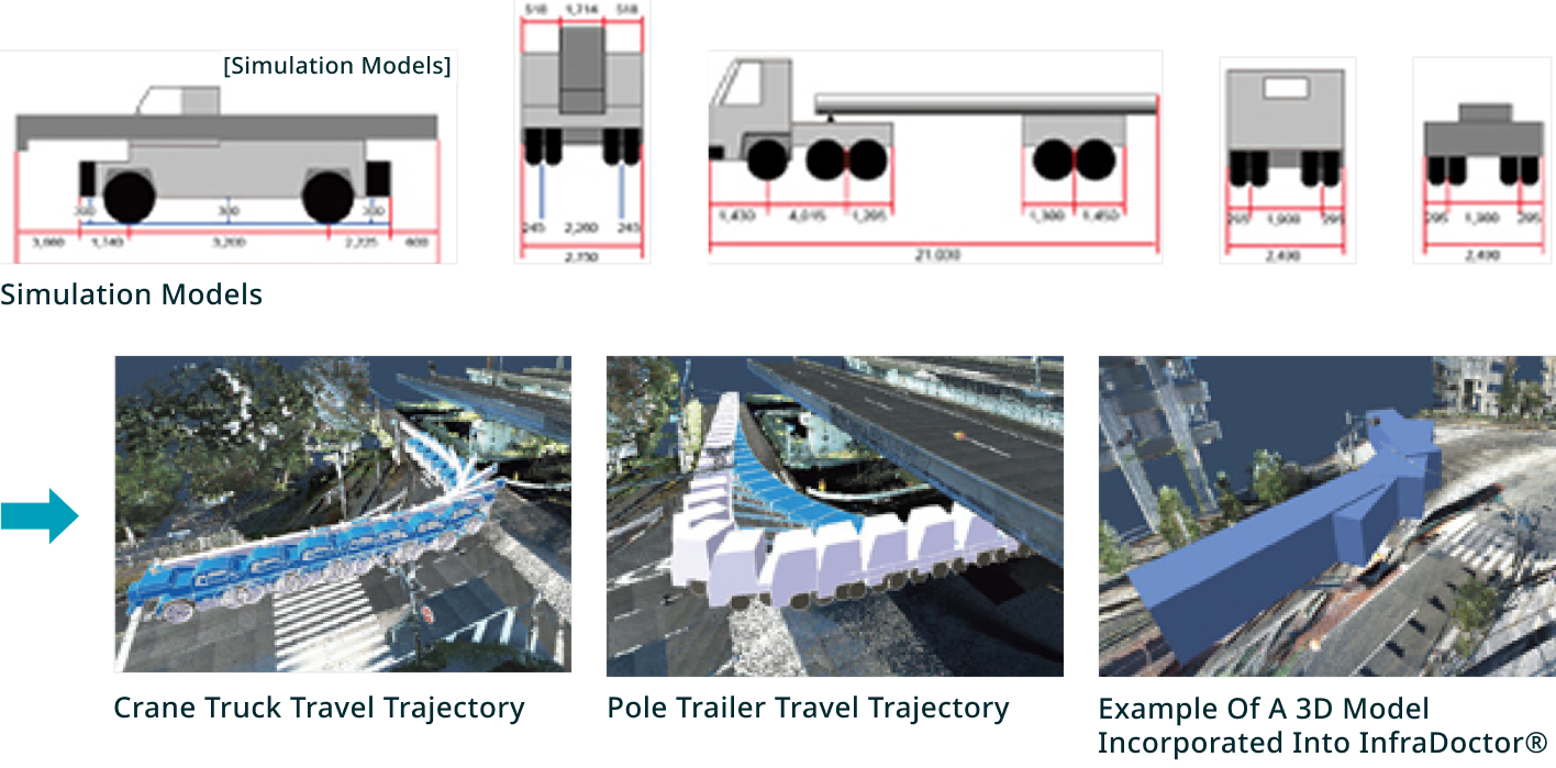
By placing 3D models reproducing special vehicle trajectories onto 3D point cloud data, trajectory studies can be conducted with full consideration of three-dimensional interactions. In addition to crane and pole trailer models included in InfraDoctor®, user-created 3D models can also be imported and used.
*Supported file formats: stl, igs, iges, stp, step, obj, wrl, wrz, vrml, enf, enf_*, drx, drx_*
Example trajectory study using InfraDoctor®
-
Inspection Vehicle Simulation Function
Using InfraDoctor®'s dynamic simulation function, 3D models of bridge inspection vehicles and other equipment can be placed on 3D point cloud data to verify actual inspection procedures in advance. This enables optimal vehicle selection and confirmation of operating procedures and potential interference with obstacles, maximizing on-site efficiency.
Verification of inspection vehicle simulation on 3D point cloud data


-
Road Surface Condition Survey
Spatial frequency analysis of 3D point cloud data enables more efficient road surface condition surveys than conventional methods. Specific functions include systematizing the process from inspection results to pavement repair planning, automating crack analysis using AI, and automating road surface unevenness detection using 3D point cloud data—all of which are expected to improve productivity.
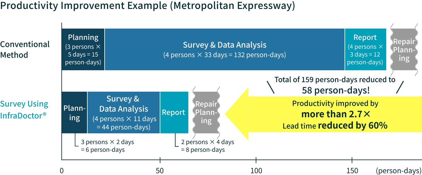
Specifically, the following functions are expected to improve productivity.
Systematizing the Process from Inspection Results
to Pavement Repair PlanningCentrally manages data obtained from inspections, enabling an efficient workflow from displaying road surface condition results to formulating repair plans. Leveraging the accumulated data enables planned and effective maintenance management, contributing to extending the service life of road facilities.
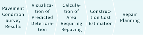


Automated Crack Analysis
Using AIA line sensor camera captures images of the road surface, and AI technology is used to automatically detect cracks and patching based on these images.


Automated Road Surface Unevenness
Detection Using 3D Point Cloud DataThe acquired point cloud data is used to detect rutting depth and flatness. Parallel processing and cloud computing enable ultra-high-speed calculations.


Applications Beyond Expressways
Applicable across diverse infrastructure sectors beyond expressways, including railways and airports.
Railway × InfraDoctor®
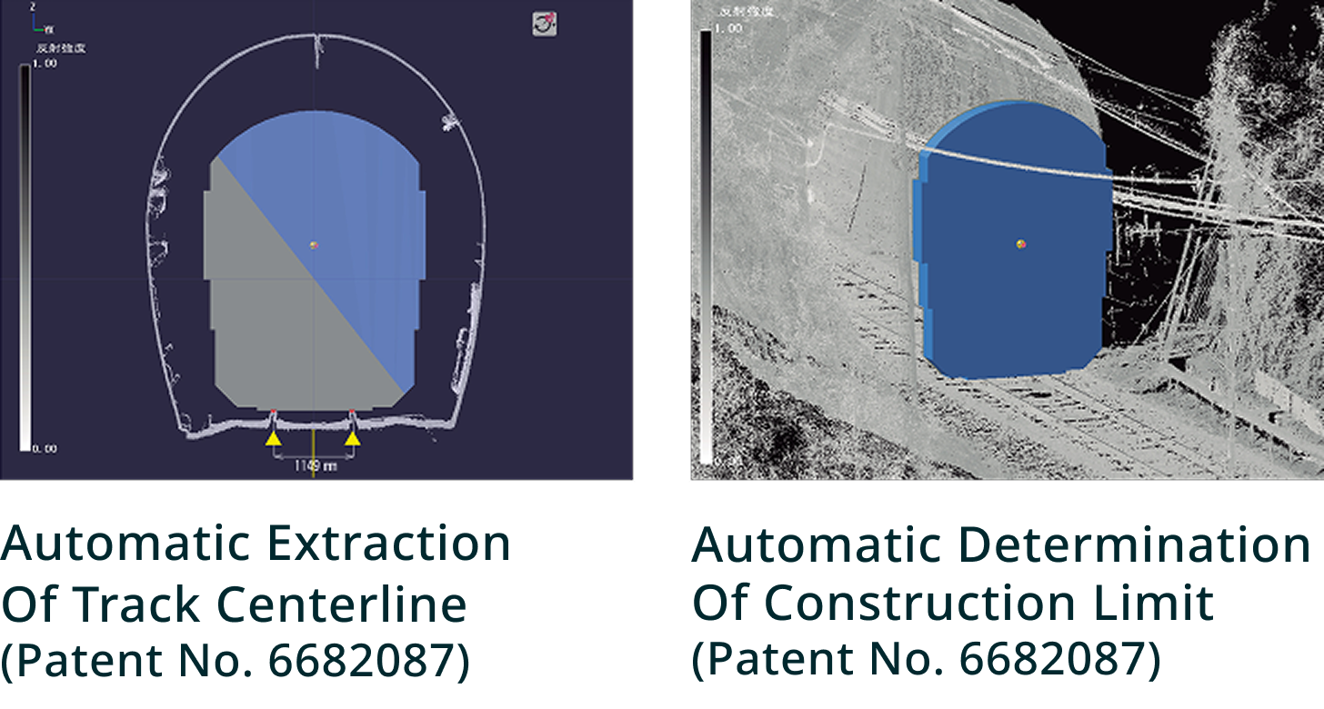
InfraDoctor® can also be applied to railway inspections, contributing to more efficient data management as well as tunnel inspections and construction limit measurements.
-
Streamlining Data Management
Registering asset registries on GIS not only reduces search time but also makes data management easier.
*The actual operational system screen may differ from the specifications shown.
-
Streamlining Inspections
3D point cloud data and high-definition digital images are acquired to conduct primary screening of tunnel inspections. The acquired 3D point cloud data can also be used for construction limit measurements.
Adoption Record (as of February 2022)
・Tokyu Corporation ・Izukyu Corporation

Airport × InfraDoctor®
InfraDoctor® is also utilized for airport maintenance and inspection. By using an MMS to conduct road surface condition surveys and periodic inspection measurements simultaneously, operational efficiency can be improved.
-
3D point cloud measurement of a runway using MMS

-
Visualization of runway surface unevenness using 3D point cloud data


Awards & Track Record
InfraDoctor® has earned high recognition alongside an extensive track record of achievements.
World First: Application of '8K' Video Technology to Road Infrastructure Inspection
Shutoko Engineering Company Limited, Aero Toyota Co., Ltd., and Astrodesign Inc. jointly launched an initiative to apply '8K' video technology—which began practical broadcasting on December 1, 2018—to road infrastructure inspection, with the aim of improving the quality and efficiency of maintenance for aging infrastructure. This application of 8K video technology to infrastructure maintenance is a world first.
Note: '8K' video refers to footage captured using an area sensor camera with approximately 33 million pixels (7,680 × 4,320).
*The company is now known as Aero Toyota Co., Ltd.
Winner of the Excellence Award at the 20th National Land Technology Development Award
The 20th National Land Technology Development Award ceremony, hosted by the Japan Institute of Country-ology and Engineering and the Coastal Development Institute of Technology, was held on July 31, 2018, at which we received the Excellence Award.
This prestigious award is presented to outstanding new technologies in the construction industry, with the aim of encouraging technology developers in their research and development efforts and raising the standards of construction technology. Our technology was highly acclaimed as the most outstanding technology in terms of novelty, versatility, and effectiveness of technology development.
Winner of the Minister of Internal Affairs and Communications Award at the 1st Infrastructure Maintenance Award
InfraDoctor® received the Minister of Internal Affairs and Communications Award at the inaugural Infrastructure Maintenance Award, established to recognize outstanding initiatives in the maintenance of social infrastructure.
InfraDoctor®'s “Development of a Road and Structure Maintenance Support System Utilizing GIS and 3D Point Cloud Data” was recognized as an innovative initiative capable of significantly improving operational efficiency and accuracy while reducing costs in infrastructure maintenance and management.

Product Brochure
You can view the InfraDoctor® brochure by downloading the following PDF files.
Technical & Product
Inquiries
If you have any questions about InfraDoctor®, please contact us using the link below.